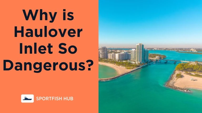
Haulover Inlet, located between Miami Beach and Bal Harbour in Florida, connects Biscayne Bay to the Atlantic Ocean. This man-made inlet was constructed in 1925 to provide ocean access for boats in the northern part of the bay.
While Haulover Inlet serves an important purpose, it has developed a notorious reputation for being extremely dangerous to navigate. But why is Haulover Inlet so Dangerous for boaters?
Factors Creating Dangerous Conditions
Several elements interact to make navigating Haulover Inlet risky:
- Strong currents – The inlet has robust tidal currents as water moves between Biscayne Bay and the ocean. These currents can reach high velocities.
- Shifting sandbars – Sandbars continuously form, shift, and change in the inlet. Their unpredictable nature poses a constant threat.
- Wind – Brisk onshore winds oppose the current outgoing from the inlet. This wind vs current battle constructs substantial waves.
- Boat traffic – As a popular boating area, Haulover Inlet gets very congested. More boats means more chances for accidents.
- Natural obstructions – Rock jetties line the inlet’s sides. Combined with the sandbars, these create navigation obstacles.
The combination of these factors makes Haulover Inlet treacherous to transit. Conditions can deteriorate rapidly even on days that seem ideal for boating.
Why Outgoing Tides Are Most Hazardous
While Haulover Inlet presents risks at any tide, outgoing tides paired with easterly winds pose the greatest danger. Here’s why:
- The outgoing tidal current reaches its peak velocity as the accumulated water in Biscayne Bay rushes out toward the ocean.
- Onshore winds blowing from the east oppose this strong outgoing flow.
- The opposing wind and current generate steep, breaking waves as they collide at the inlet’s mouth.
- Boats must pass through these turbulent waters to exit the inlet against the wind and waves.
The combination of swift currents, wind chop, and natural barriers like sandbars and jetties makes an outgoing tide at Haulover Inlet exceptionally precarious.
Navigating Haulover Inlet Safely
Despite its hazards, Haulover Inlet remains a critical passage for Miami area boaters. Here are some tips for traversing it more safely:
Check Conditions
- Monitor tide tables and weather forecasts to pick optimal times.
- Avoid outgoing tides with onshore winds for calmer seas.
- Confirm the inlet’s condition before approaching by observing from shore.
Follow Local Knowledge
- Consult experienced local boaters for advice about navigating the inlet.
- Let a knowledgeable captain lead you through the first time.
- Note which sides more captains are using – the deepest sections shift.
Ready Your Boat
- Ensure your boat has adequate power and size to handle the inlet’s waves.
- Position passengers toward the stern to avoid a bow-heavy scenario.
- Trim the bow up and throttle back to plow through waves – don’t get airborne.
Mind the Route
- Transit along the inlet’s sides, avoiding the most turbulent center area.
- Beware of shifting sandbars and natural barriers like jetties.
- Keep an eye out and steer clear of inexperienced boaters.
FAQ
-
How Deep is Haulover Inlet?
Haulover is approximately 400 ft wide and 14ft deep, although actual depths can shift over time without dredging.
-
Does Haulover Inlet Have a Speed Limit?
No, there is currently no speed limit at Haulover Inlet.
Summary
With the right preparations, conditions, and smart navigation, traversing Haulover Inlet is manageable for savvy captains. Just always respect this inlet and its infamous reputation.

